How NautiPy Works
NautiPy has two public workflows and three internal layers. The separation is partly conceptual—each layer has a different job—and partly practical: coordinate-only use does not load geodesic or scientific implementation code.
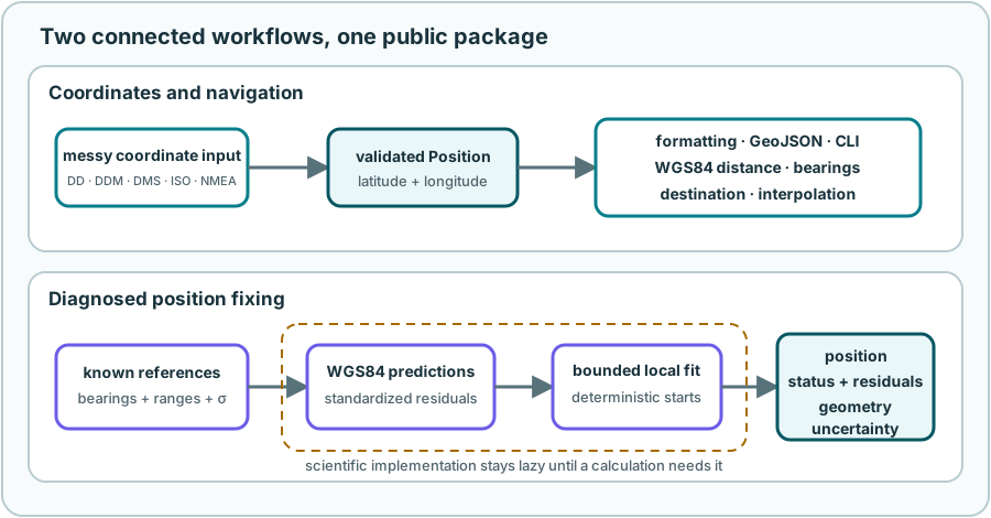
Workflow 1: text becomes a position
1. Preserve meaning while normalizing presentation
The coordinate parser can normalize whitespace, common symbols, direction words, and unambiguous decimal separators. It keeps enough source information to determine whether punctuation is a decimal mark, a component separator, or a pair separator.
2. Generate and test interpretations
An input may have evidence for a notation and axis order. NautiPy validates candidate interpretations against:
- DD, DDM, DMS, ISO 6709 subset, and NMEA-field grammar;
- latitude, longitude, minute, and second ranges;
- signs and hemisphere markers;
- named fields or GeoJSON structure; and
- the caller’s explicit
formatandorderchoices.
One valid interpretation becomes a ParseResult. Materially different valid
positions produce AmbiguousCoordinateError, not a best guess.
from nautipy import inspect_position

result = inspect_position("50° 7.3542' N; 8° 39.942' E")
print(result.position)
print(result.format)
print(result.evidence)
3. Store one simple representation
Position stores finite latitude and longitude floats in decimal degrees,
plus optional identifier and description metadata. It does not remember a
display notation: formatting is a separate boundary.
4. Send the position onward
The validated position can go to:
- coordinate formatting or inspection;
- Point and Point FeatureCollection GeoJSON interchange; or
- WGS84 distance, bearing, destination, interpolation, and nearest-position calculations.
Coordinate parsing, formatting, models, GeoJSON, and command-line plumbing use only the Python standard library. GeographicLib is loaded only when a navigation or fix calculation needs it.
Workflow 2: observations become a diagnosed fix
1. Validate the observations
BearingObservation and RangeObservation convert their references to
validated Position values. Bearings are true degrees at the unknown
position toward a reference; ranges are metres. Every observation includes a
positive one-standard-deviation uncertainty in its natural unit.
2. Declare a regional search
The solution domain is a closed WGS84-distance disk. A caller may provide its center and radius, or use a deterministic center derived from the references and the 500 km default radius.
This is an intentional regional model. Search-domain membership is measured on WGS84 rather than by checking a rectangular latitude/longitude box.
3. Search in local coordinates, predict on WGS84
The private solver works in bounded local east/north metre coordinates around an anchor. It uses deterministic multiple starting points to look for different basins.
At every trial position it predicts:
- shortest WGS84 surface distance for each range; and
- true WGS84 initial bearing from the trial position toward each bearing reference.
The residuals are divided by their observation uncertainties, then fitted by bounded nonlinear least squares. NumPy supplies arrays and linear algebra; SciPy supplies the optimizer; GeographicLib supplies the geodesic predictions.
4. Classify, do not merely return
NautiPy compares retained basins and inspects the local Jacobian. The public
FixResult reports:
- status, position, message, and warnings;
- natural and standardized residuals;
- objective and RMS fit summaries;
- rank, condition number, and degrees of freedom;
- competing positions when ambiguous; and
- local uncertainty when it is meaningful.
Raw GeographicLib dictionaries, NumPy arrays, SciPy optimizer results, and private solver state never become the public result.
Why lazy layers matter
One ordinary installation includes GeographicLib, NumPy, and SciPy, so there is no reduced edition or optional fix extra. Lazy imports still keep the conceptual boundary clean:
parse or format coordinates  → standard library only
request navigation           → add GeographicLib
request a position fix       → add NumPy and SciPy
This is about startup and separation of concerns, not about hiding features behind another installation command.
Deterministic and offline by design
Ordinary parsing and calculations:
- perform no network access;
- do not download maps, models, or data;
- do not depend on locale, wall-clock time, or random starts; and
- use explicit WGS84, metre, and true-bearing conventions.
That makes examples reproducible. It does not make source observations more accurate or turn the package into certified navigation equipment.
What NautiPy deliberately does not do
NautiPy is not a general GIS, chart display, route planner, live GPS reader, AIS client, weather service, arbitrary coordinate-reference-system engine, or magnetic model. Those are separate domains with separate data and safety requirements.
The exact design contracts are the product direction, architecture and dependency policy, coordinate specification, navigation specification, GeoJSON specification, and position-fix specification.
Continue with Practical Use or return to the learning path.