Navigation on an Ellipsoid
On a flat sheet, the shortest route between two points is a straight line. Earth is curved and slightly flattened at the poles, so dependable global navigation needs a different model.
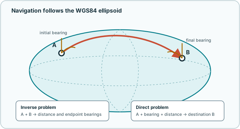
WGS 84 represents the reference surface as an oblate ellipsoid. A geodesic is the locally straight path on that surface. NautiPy uses GeographicLib to solve WGS84 geodesic problems rather than substituting a sphere.
Two complementary questions
Geodesic navigation is commonly divided into two problems:
- Inverse: given the start and end, find the shortest surface distance and endpoint bearings.
- Direct: given a start, initial bearing, and distance, find the destination.
NautiPy uses metres for distance and true degrees clockwise from north for bearings. Zero degrees is north, 90° east, 180° south, and 270° west.
The inverse problem
from nautipy import Position, inverse

start = Position(50.12257, 8.66570)
end = Position(53.55110, 9.99370)

result = inverse(start, end)

print(result.distance)
print(result.initial_bearing)
print(result.final_bearing)
The initial bearing is the forward direction at the start. The final bearing is the forward direction on arrival while continuing along the same geodesic. It is not the bearing from the endpoint back to the start.
Why can the two forward bearings differ? Lines of longitude converge toward the poles, so the geodesic’s direction relative to local north changes along most routes.
For concise calculations, distance(start, end) and
initial_bearing(start, end) wrap the same inverse solution.
The direct problem
from nautipy import destination, distance

start = "50.12257, 8.66570"
end = destination(start, bearing=90, distance=12_000)

assert abs(distance(start, end) - 12_000) < 1e-6
The bearing may be any finite real number; NautiPy normalizes it modulo 360°. Distance must be finite and non-negative. A zero-distance destination is the validated starting position.
Positions along a route
interpolate follows the selected shortest WGS84 geodesic. Its fraction is a
share of geodesic distance, not a linear average of latitude and longitude.
from nautipy import interpolate

quarter = interpolate(start, end, fraction=0.25)
midpoint = interpolate(start, end)  # fraction=0.5
Fractions stay in [0, 1]; the function does not extrapolate. The boundary
values return the validated endpoints exactly.
To choose the closest member of an ordinary iterable:
from nautipy import nearest_position

closest = nearest_position(
    start,
    [
        "50.20, 8.70",
        "50.13, 8.67",
        "50.30, 8.90",
    ],
)
Exact-distance ties keep the first candidate, and invalid candidates are not silently skipped.
Difficult geography
Antimeridian
The antimeridian is where
longitude changes between +180° and −180°. A short geodesic can cross that
numbering seam without making a nearly complete trip around Earth. NautiPy’s
generated longitudes remain in [-180, 180].
Poles
Longitude lines meet at a pole. Bearings are local directions, so polar and near-polar geometry deserves care even though the ellipsoidal solver handles the WGS84 surface.
Coincident positions
The distance from a position to itself is zero, but there is no unique
direction to travel. inverse therefore reports both bearings as None, and
initial_bearing raises NavigationError.
Multiple shortest geodesics
Some widely separated endpoints admit more than one equally short geodesic. NautiPy returns GeographicLib’s deterministic canonical solution. Near antipodal geometry is also outside the intended regional use of the position fixer.
What the numbers mean
The output is a deterministic calculation from the coordinates you supplied. A sub-millimetre numerical agreement does not imply that the source coordinates are known that accurately. WGS84 is a reference ellipsoid; it does not model tides, currents, terrain, magnetic variation, or the vessel’s motion.
For exact boundaries and errors, see the navigation behavior specification.
Navigation safety
These calculations are not certified navigation equipment and should not be the only basis for a safety-critical decision.
Learn more
- Geodesics on an ellipsoid gives an approachable mathematical overview.
- Azimuth explains clockwise angular direction from a reference north.
- The US National Geospatial-Intelligence Agency maintains the WGS 84 reference material.
- Charles F. F. Karney’s paper, Algorithms for geodesics, describes the numerical algorithms used by GeographicLib.
- The open GeographicLib geodesic documentation documents the underlying implementation interface.
Next: Finding the Boat.