Coordinates on Earth
A geographic position answers two questions: how far north or south of the equator, and how far east or west around Earth? The answers are latitude and longitude.
NautiPy stores both as decimal degrees:
Latitude must be between −90° and 90°. Longitude must be between −180° and 180°. NautiPy rejects values outside those ranges instead of wrapping them.
One place, several notations
Degrees may be subdivided in two familiar sexagesimal ways. One degree contains 60 minutes, and one minute contains 60 seconds.
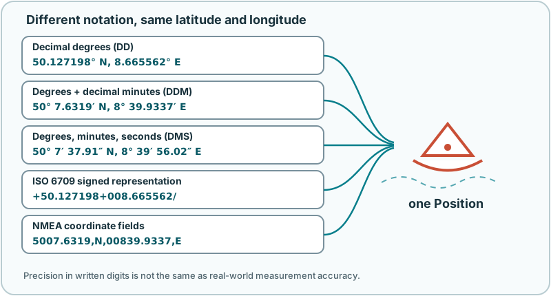
| Name | Example | What is fractional? |
|---|---|---|
| Decimal degrees (DD) | 50.122570, 8.665700 |
degrees |
| Degrees and decimal minutes (DDM) | 50° 7.3542′ N; 8° 39.9420′ E |
minutes |
| Degrees, minutes, seconds (DMS) | 50° 7′ 21.25″ N; 8° 39′ 56.52″ E |
seconds |
| ISO 6709 subset | +50.122570+008.665700/ |
least-significant unit |
| NMEA coordinate fields | 5007.3542,N,00839.9420,E |
minutes |
DD, DDM, and DMS describe the same angles. ISO 6709 defines representations for exchanging point coordinates; NautiPy deliberately supports an unambiguous, two-dimensional signed subset. NMEA fields are the coordinate and direction fields used in marine electronics, not complete NMEA sentences.
You do not need to identify the notation first:
from nautipy import format_position, parse_position

position = parse_position("50° 7.3542' N; 8° 39.942' E")

assert format_position(position, to="dd") == "50.122570, 8.665700"
assert (
    format_position(position, to="dms")
    == "50° 7′ 21.25″ N; 8° 39′ 56.52″ E"
)
The parser accepts harmless differences such as common prime symbols, direction words, whitespace, and unambiguous decimal commas. It still validates every component: minutes and seconds must be below 60, and 90° latitude or 180° longitude cannot have a non-zero remainder.
Coordinate order changes the place
The pair (50, 8) and the pair (8, 50) are both valid, but they are far
apart. A parser cannot safely infer which one a person intended.
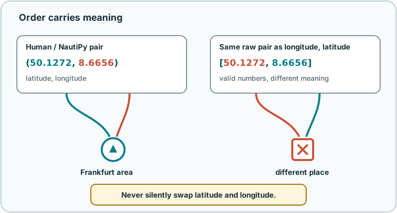
NautiPy follows explicit evidence:
- The default
order="latlon"treats the first unmarked component as latitude. order="lonlat"treats the first unmarked component as longitude.order="auto"requires hard evidence such as hemisphere markers, named fields, NMEA widths, GeoJSON structure, or a value that cannot be latitude.- If both unmarked values fit either axis,
order="auto"raisesAmbiguousCoordinateErrorrather than using geography or likelihood to guess.
from nautipy import parse_position

latlon = parse_position((50.12257, 8.66570))
lonlat = parse_position((8.66570, 50.12257), order="lonlat")

assert latlon == lonlat
Named data is clearer still:
The GeoJSON exception
GeoJSON specifies coordinates in longitude, latitude order. NautiPy honors that rule for a GeoJSON Point:
That order belongs to GeoJSON structure. It does not silently carry over to an ordinary Python list or tuple.
Inspect before converting
inspect_position explains how an input was understood. This is useful when
teaching, importing unfamiliar data, or diagnosing a rejected value.
from nautipy import inspect_position

inspection = inspect_position("5007.3542,N,00839.9420,E")

print(inspection.format)               # nmea
print(inspection.position)
print(inspection.source_order)
print(inspection.normalizations)
print(inspection.latitude_resolution)
Inspection records the detected component formats, order evidence,
normalizations, source text, inferred angular resolution, and candidate
interpretations. If materially different interpretations remain, it raises an
ambiguity error whose candidates describe the competition.
Inspect a batch without losing failures
inspect_positions applies the same rules independently to each yielded
record. It preserves source order and zero-based indices, so invalid or
ambiguous input cannot disappear between the original data and the result.
from nautipy import BatchInspectionFailure, inspect_positions

batch = inspect_positions(
    [
        "5007.3542,N,00839.9420,E",
        "50, 8",
        "not a coordinate",
    ],
    order="auto",
)

assert batch.total_count == 3
assert batch.parsed_count == 1
assert batch.ambiguous_count == 1
assert batch.invalid_count == 1

for item in batch.items:
    if isinstance(item, BatchInspectionFailure):
        print(item.index, item.error_type.__name__, item.message)
    else:
        print(item.index, item.result.position)
Collect mode is the default: successful ParseResult values and structured
coordinate failures remain together in order. Raise mode stops at the first
coordinate failure and reports its positions[index]. Neither mode changes
the scalar parser's rules or guesses an axis order.
The outer value is always the collection. A string, bytes or bytearray value,
mapping, or Position is therefore rejected as the batch itself, while every
other sequence is treated as a sequence of records. Wrap numeric position
pairs in an outer collection, for example
[(50.12257, 8.66570), (51.0, 9.0)].
Precision is not accuracy
Writing more digits makes a representation more precise, but it does not make
the measurement more accurate. 50.122570 has a finer displayed increment
than 50.12; that says nothing by itself about the sensor, survey, datum, or
age of the source.
NautiPy can infer the lexical angular resolution of many text inputs. It uses
that resolution to avoid needlessly coarse conversion when precision=None.
It does not turn source resolution into measurement uncertainty.
This distinction also appears in RFC 7946’s discussion of coordinate precision.
Boundaries and limitations
- Positions are two-dimensional. Altitude, depth, and extra numeric fields are rejected.
- The coordinate layer does not transform datums or arbitrary coordinate reference systems.
- NautiPy accepts NMEA coordinate fields, not
$GPGGA,$GPRMC, or other complete messages. - It does not repair corrupted input, infer operating-system locale, or guess a location from plausibility.
- A valid coordinate is not necessarily an accurate or current observation.
For exact accepted forms and failure behavior, see the coordinate behavior specification and the GeoJSON behavior specification.
Learn more
- Geographic coordinate system gives a friendly overview of latitude and longitude.
- Sexagesimal notation explains the base-60 division behind minutes and seconds.
- ISO 6709:2022 is the primary coordinate-representation standard.
- RFC 7946 defines GeoJSON, including its coordinate order.
- The NMEA 0183 standard page describes the marine data standard from which NMEA coordinate fields come.
Next: Navigation on an Ellipsoid.